


Geography
Jeollanamdo is
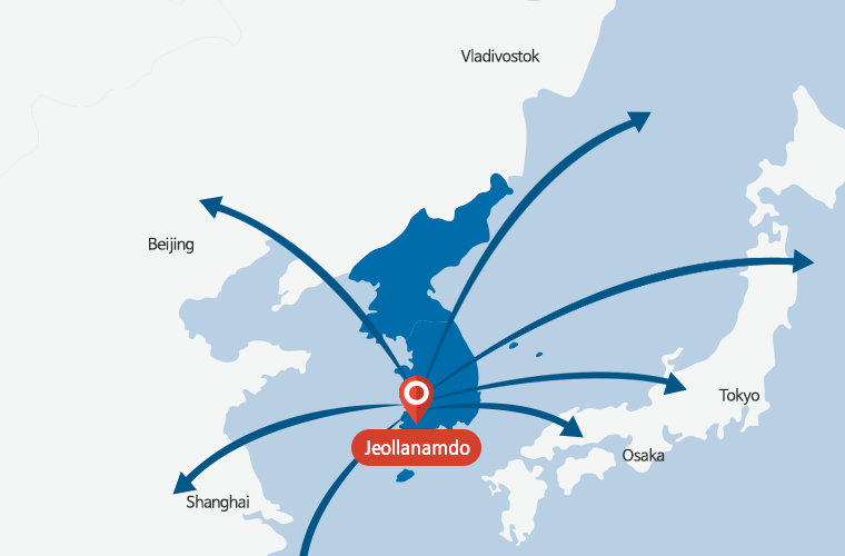
located in the south-western part of Korea, in Northeast Asia.
Jeollanamdo faces China across the ocean to the west and Japan to the south-east, which makes it a hub of Northeast Asia, a starting point of Europe and Asia, and a gateway to the Pacific Ocean.
Rivers flowing across Jeollanamdo provide fertile farmlands by creating vast plains southwest and northwest of the river basins. There are three primary rivers in the region: Yeongsangang River, which flows into Mokpo Bay; Seomjingang River, which originates in Jeollabukdo and flows down the eastern mountainous terrains in Jeollanamdo and Jeollabukdo; and Tamjingang River, which flows through Jangheung-gun and Gangjin-gun. Regarding the plains of Jeollanamdo’s, Naju Plain in the Yeongsangang River basin and Honam Plain in Jeollabukdo are some of Korea’s most prominent granaries.
Zenith of Longitude and Latitude
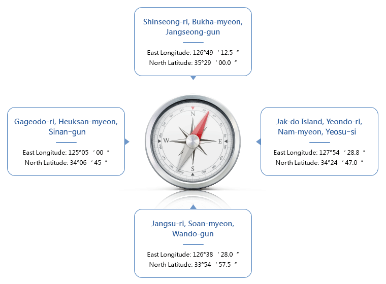
| Location of Jeollanamdo Provincial Government | Zenith of Longitude and Latitude | Distance(㎞) | |||
|---|---|---|---|---|---|
| Direction | Location | Zenith | |||
| East Longitude | North Latitude | ||||
| 1 Oryong-gil, Sanhyang-eup, Muan-gun, Jeollanam-do | East | Jak-do Island, Yeondo-ri, Nam-myeon, Yeosu-si | 127°54‘ 28.8“ | 34°24‘ 47.0“ | East-West Between the zenith: 262.8 km Between land and sea: 145.3 km South-North Between the zenith: 175.9 km Between land and sea: 136.4 km |
| West | Gageodo-ri, Heuksan-myeon, Sinan-gun | 125°05‘ 00“ | 34°06‘ 45“ | ||
| South | Jangsu-ri, Soan-myeon, Wando-gun | 126°38‘ 28.0“ | 33°54‘ 57.5“ | ||
| North | Shinseong-ri, Bukha-myeon, Jangseong-gun | 126°49‘ 12.5“ | 35°29‘ 00.0“ | ||
Location
- Located in the south-western part of the Korean Peninsula
- Peaks of the Sobaek Mountain Range bordering Gyeongsangnamdo to the east
- Low hilly terrains of the Noryeong Mountain Range bordering Jeollabukdo to the west
Geological Characteristics
- "East High West Low" and “North High South Low”
- Terrain is more alpine to the east than to the north
- Heavily indented coast in south-western area
- With 2,165 islands, comprising 65% of the entire Korean islands. (Source: Ocean & Ports Division (2017))